Introduction
I like maps.
Okay, you got me. I love maps,1 hence the title of this article (hopefully there will be many more moments of mania over maps to come). It began with memorising them blindly because I thought it was cool, progressed to using the world map as a tool to think about geopolitical issues because I wanted to convince myself that it was ‘useful knowledge’, and ended with me accepting that I was inordinately delighted by maps whether or not they proved to be useful, thus allowing me to devour random geographical facts without shame or care for their application. Knowledge for its own sake, I suppose.2
This article presents one such collection of 'random geographical facts' — namely about landlocked countries.
Let's dive right in, shall we?3
Landlocked
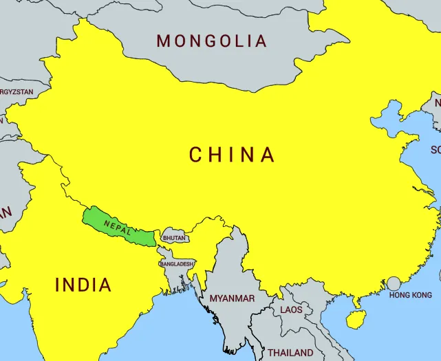
A landlocked country is a country which does not border any open seas (remember this term for later). For instance, Nepal is landlocked by China and India. About 25% of the world’s countries are landlocked (the exact number depends on which territories you consider to be countries).
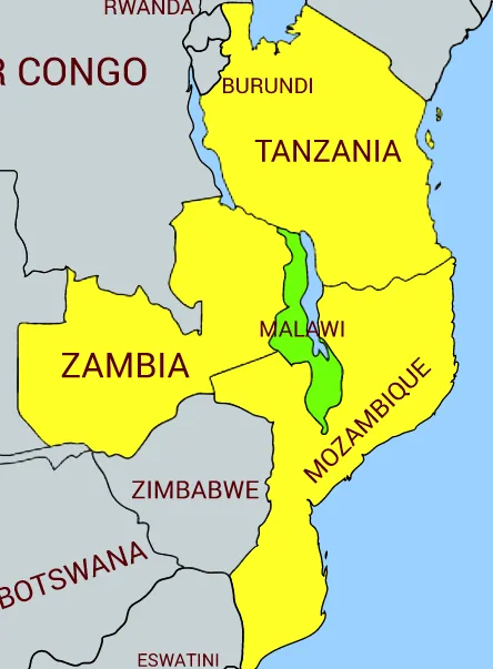
The open sea border qualification means that a country is considered landlocked even if it borders a ‘closed’ body of water. For instance, even though Malawi is bordered to the northeast by Lake Malawi, it is considered landlocked (by Tanzania, Mozambique, and Zambia) because Lake Malawi is a ‘closed’ body of water. I suppose the idea here is that you can only escaped being landlocked if you can escape into international waters where no country has jurisdiction over you, so a country bordered by a closed sea is still considered landlocked.
Doubly Landlocked
A doubly landlocked country is a country which is landlocked by countries which are themselves landlocked.
There are only two such countries in the world.
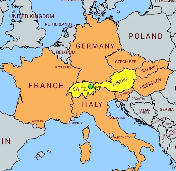
The first is Liechtenstein (the green dot), one of the 6 European micro-nations (the other 5 are Andorra, Monaco, San Marino, Vatican City, and Malta — all are shown in this pic, except for Malta). It is landlocked by Switzerland (itself landlocked by Italy, France, Germany, Liechtenstein, and Austria) and Austria (itself landlocked by Germany, Czech Republic, Slovakia, Hungary, Slovenia, Italy, Liechtenstein, and Switzerland).
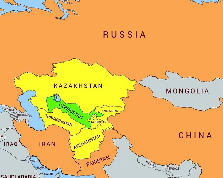
The second is, very surprisingly given its size, Uzbekistan (in green). It is landlocked by 5 ‘stans’ shown in yellow — Kazakhstan, Turkmenistan, Afghanistan, Tajikistan, and Kyrgryzstan. The 5 ‘stans’ are themselves landlocked by a combination of each other + Russia, China, Pakistan, and Iran. Although it appears that Kazakhstan and Turkmenistan have a coastal border, that seemingly large body of water is the Caspian Sea, which is a ‘closed sea’. To avoid being landlocked, a border with an ‘open sea’ is required.
Enclaved
Finally, an enclaved country is a special case of a landlocked country which is landlocked by only 1 other country. In short, it lies completely within the borders of a single other country.
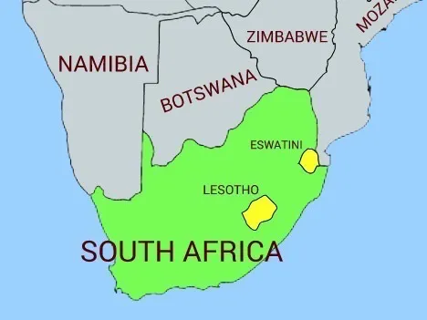
One example is Lesotho (shown here, within SA). There are only 2 others in the world — San Marino and Vatican City, both within Italy (visible on the map highlighting Liechtenstein above). Eswatini (formerly Swaziland until 2018) would be enclaved but for its north-eastern border with Mozambique.
So What?
Okay Thevesh, I've humoured you and read up to this point. Am I supposed to feel something now?
Nope, nothing at all! I wrote this because I thought it was interesting, nothing more, nothing less. I suppose I could make the argument that you should know about landlocked countries in case you commit a crime in future and need to set up camp somewhere you can get to international waters, but I'm pretty sure you'll figure it out on your own if you're ever in that situation.
Till the next MapMania!
Footnotes
If you love maps too, consider checking out the geography quizzes on Jetpunk — they may bring you many hours of fun. ↩
This is actually reproduced from an article I wrote on Medium in 2019. I'm republishing it because I still like it 5 years later in 2024. Coincidentally,I ended up beginning my PhD in geography this year (part-time, while working full-time, for the pure joy of it). Go figure. I guess the signs were always there, eh? ↩
All maps generated using mapchart.net. ↩